
The Prelude II:
Port Augusta to Townsville
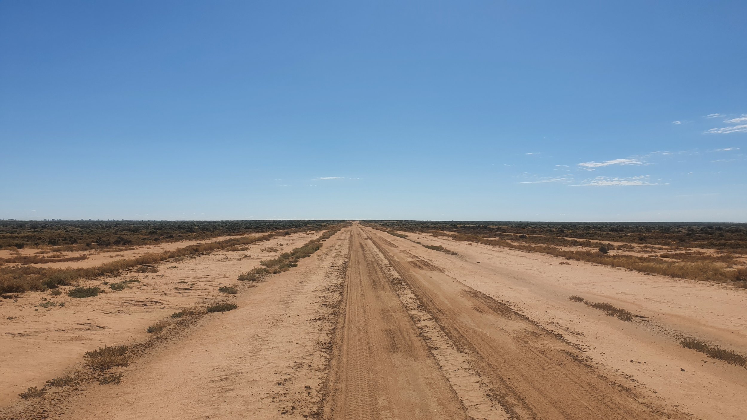
1030hrs Wednesday 26th January 2022. Heading east on Clare Mossgiel Road (130km west of Hillston). Today is day 09 (Strava link) of my Melbourne to Sydney trip. I'm being chased by a thunderstorm that will hit me tomorrow.
The route
There are many ways to cross Australia. Port Augusta to Townsville would have to be one of the least well-known.
By the time you read this, I'll be out in the heart of Australia riding my bike, solo and self-supported on what I am calling 'The Prelude'. 2,700km through arid and semi-arid deserts pushing up into the tropics and back out to the coast. I'll be riding the Birdsville Track, known as a famous 4WD route; avoided in summer even by those with air-conditioned vehicles.
This ride sets out to achieve one outcome - to prove that I can traverse Australia by bike in a way that few, if any, people do. I describe my philosophy as 'the hard way'.
I’ve written this page in an order I think makes sense for the reader. If you want to skip ahead and look at the detailed route information then scroll down or click here.
I know of no better life purpose than to perish in attempting the great and impossible. The fact that something seems impossible shouldn't be a reason not to pursue it, that's exactly what makes it worth pursuing. Where would the courage and greatness be if success was certain and there was no risk? The only true failure is shrinking away from life's challenges.
Chris Williamson in conversation with David Goggins (quote attributed to Neitzsche) on How to Build Unshakable Confidence
Want to follow along?
Join the Discord group. This is my primary form of communication. If you want the whole experience go here.
Instagram. I post an update daily (when I have reception) with one photo that captures the moment.
Strava. I post my interesting activities on Strava. I train 1,000+ hours a year. I am not going to fill your feed with boring stuff.
Email list. You can sign up on the website. I use the email list infrequently to send out updates.
Contact point for media, brand partnerships and digital high-fives: adventure@thehardway.cc

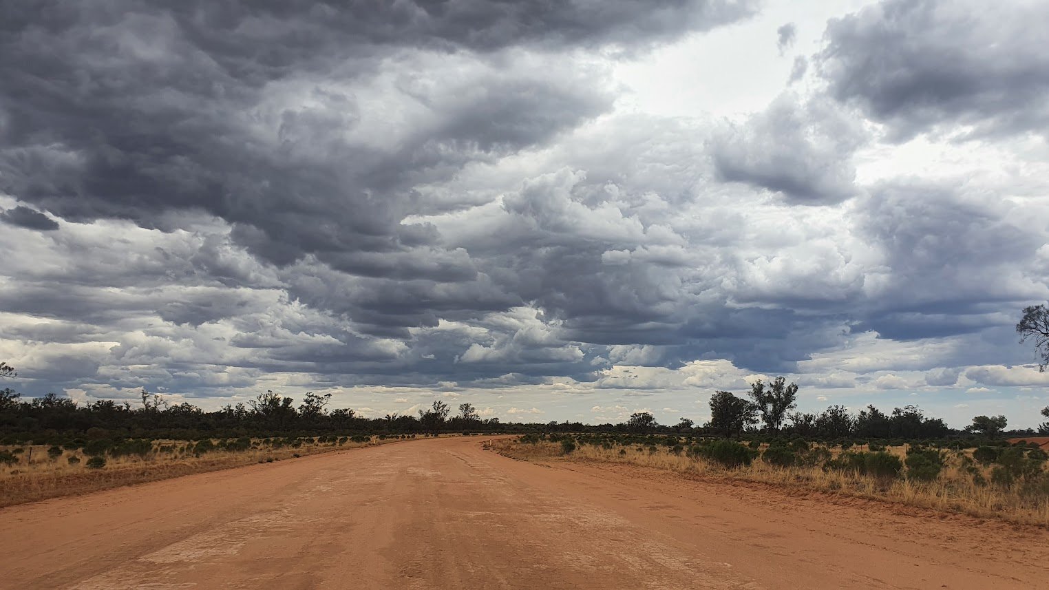
1645hrs Sunday 27th March 2022. Heading south on Brayton Road. Brayton is home to the five-way intersection. Having ridden across Swallow Tail Pass, I didn't think the road could get worse. I was wrong. I came around the corner to find this truck stuck. Multiple attempts to remove the truck had failed. This is part of a classic 200km+ gravel ride I found looking at Google Maps (Strava link). My first time riding this in August 2020 reminds me of what I was willing to set out and do (Strava link).
I came riding here to find joy in riding again after feeling flat returning from my first multi-week trip. This didn't fix the problem, but the ride gave me a lot of cleaning to do when I got home.
The philosophy
The Hard Way is the belief in creating situations of difficulty and backing ourselves through preparation and experience. By choosing to do this, we're creating the defining memories of our lives. - The Hard Way Manifesto.
In 2020 I started riding my bike distances I couldn't have conceived only a year earlier. This was my first (and last) weekend ride. 600km via Crookwell & Katoomba. Saturday, Sunday & Monday. I was a little optimistic in my planning. What would be a defining ride for many experienced people was my first overnighter.
I started adding the following sentence to the start of my posts.
"I say this not to make a point that somehow I should be celebrated, but to share the great joy we all have access to. It's all there. I just wish more people would go out and get it."
I look back and think I was close to the formative idea. I want to share this experience not to inspire people, not to prove them wrong but to show everyone what's out here for all of us to experience. I understand that few if any, people will see what I do and follow along the way I do. I hope people embrace the idea of the 1% club.
I speak and train corporates professionally and draw on endurance athletics and my PhD in applied statistics to improve the bottom line of organisations.
I sign off many of my Strava essays as I have for several years now. Every time I think I might have progressed and what I am about to say is not true, I realise I have not raised my gaze high enough.
"I'm only just getting started. Are you?"
Andrew Pratley

"People get obsessed with the physicality, but I believe the mental approach is the most important in life, in general — whatever endeavour you choose to undertake." [John Muir]
"If you get your mental approach right, the body will follow."
That is especially evident when you are in the Australian outback with no one around, dwindling food and water and the sun boring down on you.
"When you're on the brink of survival, nothing is monotonous," he said.
"When you could die any day from a mistake you make, you have to stay on top of your mind."
John Muir - adventurer and receipt of the Lifetime of Adventure award by the Australian Geographic Society
1430hrs Monday 24th January 2022. Heading north on Arumpo Road (Street View from 2008). I'm a few kilometres away from what will be one of the most profound and defining life experiences I'll ever have. Not that I know this yet.
This is what I posted on Strava:
"I stopped in today to see my mate from yesterday. He was out, so I filled up my water bottles and gave his dog a quick pat. As I am walking back to the bike I see this one square metre of grass he's growing, I guess for the dog.
I cried.
Here's a guy living in an abandoned house, working for $30/hr driving heavy machine in the middle of fucking nowhere to pay for his ongoing chemotherapy for stomach cancer in 2008 (he was only meant to last a year) and all he's got to come home to is his dog and the grass he's growing.
As I rode off, it really hit me, for everything I have (including with me), the bike, the gear, the opportunity to do this, I have even less. I don't even have a dog to come home to, I've got a giant stuffed Wolf. I reckon I cried for the best part of an hour thinking about that until the heat, the flies and sand resumed their place as my focus."
Over the coming days, I'll codify an approach I've been using and convince myself I know what I am doing with not one person backing me apart from myself. I have never been so focussed on the experience of life as I was out here. John Muir is right, nothing is monotonous.
The bike
Bike, gear and sponsors
The route (in detail)
Trip planning is more art than science (coming from someone with a PhD in applied statistics). The genesis of this trip was riding the Birdsville Track in summer. I've only found one other group that has done this. I am sure I am not the first person to do this solo in summer.
I've quickly realised that it's often as much time, effort and hassle to get to the start of somewhere like the Birdsville Track via car as it is to ride. Adelaide is the obvious starting point. I'll be leaving from there in November and wanted to ride somewhere different. I settled on Port Augusta, not realising there are no flights. It’s a bus to the start.
Port Augusta is an interesting town. The two north-south routes through Australia both originate from Port Augusta. Port August is arguably one of the more remote liveable places in Australia.
There are four sections to the ride:
Part I: Port Augusta to Marree ~ 675km (six seven+ hard days)
The first part of the ride is an odd combination of the some of the easiest (fastest) and hardest riding I'll experience on the trip. Smooth, flat and fast highways and remote unnamed tracks between stations possibly crossing 6m high sand dunes.
Marree the southern end of the Birdsville Track is almost directly north of Port Augusta. You can either head west or east around Lake Torrens. I decide to go west and approach Marree via the Oodnadatta Track. The easy option is Stuart Highway, Olympic Dam Highway, Borefield Road and Oodnadatta Track.
I've made a few deviations. 10km from Port Augusta, I am heading west before rejoining the Stuart Highway at 130km. This section is to test the bike in rougher conditions whilst I am still close to a major town and can come back and make changes. There are various access roads that run parallel to the Stuart Highway, it's hard to make a judgement about using these or not. I'll have a look when I am out there. At 225km, I am heading east, turning onto T294 (Street View) take a 40km side track into Woomera. This allows me to see the conditions of the area and be off the highway for a short section.
One of the early iterations of the route was to head north from Andamooka, going around the top of Lake Torrens, and turning onto Mulgaria Road (where there is a station). I contacted Andamooka about this as is so often the case, I did not receive a response. Google Maps estimates the distance at 80km with a riding time of four hours. The Geoscience Australia 1:250 000 H5312 - Andamooka topographic map tells a different story. This route crosses directly through sections of sand ridges that vary from 4m up to 6m. I could easily spend the best part of 80km pushing my bike and trailer. At 2-3km/hr that's not going to be achievable.
There are two other approaches. The more direct is to head east at Purple Downs (this is very sandy). The route I’ve settled on is to leave Woomera and head for Arcoona on Bosworth Road (Street View) ~ 20km. Aracoona to Andamooka is ~80km from the H5312 Andamooka topographic map a relatively straightforward ride to Andamooka Station. North of Andamooka Station the track skirts the edges of sand dunes and crosses one small section (5km ish). That section alone could take hours if I have to disconnect the trailer and make multiple trips across the sand ridges. Or it might be fine with a bit of pushing.

Extract from SH53 (1st Edition) Tarcoola 1:1 000 000 topographic map Geoscience Australia. Download page for Tarcoola. There are 49 maps at 1:1 000 000 that cover the entire continent. The index for 1:1 000 000 maps is here. The website for all topographic maps is here.
At Andamooka, I'm on a sealed road to Roxby Downs (my first and only supermarket stop until Longreach), then I'm on Borefield Road, which according to my research, is generally pretty good. This area had a lot of rain in the past few months, which generally degrades conditions.
Roxby Downs to Marree is just under 200km. That's a long way to go without a refill point. I have two options. My original plan was to head west off Borefield Road and go to Stuart Creek Station (whom I emailed but did not reply). This track looks rugged and possibly sandy, ~ 20km. If I take this route, that's 125km from Roxby Downs, then roughly another 125km to Marree. The detour adds 50km of private property riding.
The alternative is to stay on Borefield Road and ride to Callanna, which is 140km from Roxby Downs. Overall I'd guess this is a similar ride time. I'll decide based on how the earlier off-road sections have gone, how I feel, and how much time pressure I feel.
I also have to ask myself how many times do I want to try and cross six-metre-high dunes on a 29+ bike with a heavy trailer. A year ago, the answer to the question would have been zero. Now it’s greater than that. How our lives change.

Extract from SH53-08 (2nd Edition) Curdimurka 1:250 000 topographic map Geoscience Australia. Download page for Curdimurka. There are 513 maps at 1:250 000 that cover the entire continent. The index for 1:250 000 maps is here. The website for all topographic maps is here.
I'll spend a day in Marree repacking my gear, updating the world on the trip and looking at the weather for the next section. This section has taken more time to plan and refine than I could have imagined. The area is remote, there is little if any useful information online and I don’t have someone to ask about the area. These difficulties make this exciting. My guess is I will have spent as much time planning this section as I’ll spend riding.
Part II: Marree to Birdsville (520km 5+ hard days)
Navigation doesn't get much easier than the Birdsville Track. There is the option of the Inside Track (which is often closed - for good reason). The South Australia Government updates the Outback Road Warnings regularly. Leaving Marree, you head north for 500km. Not long after crossing the border, you're in Birdsville. There's one pub along the way, a few camp spots and enough stations to make the ride doable in summer.

Extract from SG54 (1st Edition) Cooper Creek 1:1 000 000 topographic map Geoscience Australia. Download page for Cooper Creek. There are 49 maps at 1:1 000 000 that cover the entire continent. The index for 1:1 000 000 maps is here. The website for all topographic maps is here.
I've previously posted on Bikepacking Australia facebook page about my approach of relying on private properties for water. Here's an extract:
"Going back to an earlier point - you can't rely on stations. In my opinion, this is the discussion to have (if people want to). The best way to have a discussion/disagreement/argument is for each person to put forward their weakest areas and then have the other side build on this, not to obfuscate, deceive and win moot points. This requires good faith on both sides and taking away the desire to 'win'. If you want to criticise a trip like this, in my opinion, it's on the legality, morality and ethics of assuming you can turn up to someone’s place and expect them to give you water. Over time I have developed a view that this is fine. People seem happy to host me briefly, that the conversation is interesting enough to offset the issue of me turning up unannounced. I reckon I have done this somewhere between 20-30 times in the last 18 months. If I started to get more (some/any) negative reactions in the future, I'd revaluate my opinion. I cannot think of one person that has turned me down or even been standoffish. The closest I've was a guy out near Mount Irvine who watched me fill up from his tap - I think he was perplexed by the entire situation. My general experience is that people welcome me and invite me to come back (and mean it). Sometimes I do visit again, and they remember me. It must be the hair."
Riding the Birdsville Track in summer using only publicly available water sources would be very hard. The focus on publicly available water sources comes from bikepack racing. Whilst I have great respect for the sport, and admiration for those at the front, I have no interest in arbitrary rules. This is part of the reason I choose not to participate in these events. This seems akin to being told you must ride a rim-brake bike. I'd argue the future of bikepack racing is western countries is a lot more complicated than anyone wants to accept.
There's more information on riding the Birdsville Track than on any other part of this route. Kenney Mac (B4B) has a page, as does Paul (Bloke On Bike) and GJ Coop (Cycle Trails Australia). All three agreed that "It’s way too hot during summer, the average maximum temperature for the months November to March in Birdsville is over 35ºC." There's a certain appeal to being out here when you know one else will be.
The longest section between stations is about 165km Clifton Hills to Pandie Pandie. This is in the last 200km, I should have a good idea of water consumption and can plan accordingly. By this stage I should have quite the taste for bore water. Given how much I like salt, this might not be the worst outcome. Or, as is far more likely, it will be awful.
Part III: Birdsville to Longreach (725km 7+ hard days)
It's hard to imagine leaving the Birdsville Track and being in a more remote part of Australia. Channel Country offers just that. Tanbar is the only 'place' shown on Google Maps between Birdsville and Windorah ~ 380km. Street View from December 2022 shows there isn't even a discernible road, let alone a sign. No sign of civilisation in sight!
This section of the route has been the hardest to plan and has the most uncertainty. I can't find anyone that's ridden through here. Those going east-west seem to pick a more northerly line than I have.
Channel Country is described as a 'desert that floods'. Covering roughly a quarter of the state, the area has a few thousand people living out here.
Planning this section I had the choice of either Winton or Longreach as my last major stop. I choose Longreach for no other reason than I thought it might be nice to go to a supermarket. I'm one of those rare people that goes grocery shopping multiple times a week (I eat a lot) and for the most part enjoy the experience. I've thought about writing a book exploring how supermarkets define nations. My working hypothesis is that supermarkets mirror and shape how nations eat. By looking at where and how people buy their food you can understand their culture. I present the US and Japan as examples. Two very different countries with their approach to how they eat and supermarkets that couldn't be more different.
There is no direct route from Birdsville to Longreach. Although this area is considered a desert (based on rainfall) the Diamantina River is between Birdsville and Longreach. You need to head north and east. The order of those choices determines the route. North to Boulia then east to Winton would be the most well travelled and populated route. Winton is the start of the Outback Way - Australia's longest shortcut. I decided to head east along Birdsville Development Road (which Google has recently mapped parts of with Street View - only parts, which seems odd. How did they get to Birdsville...?). Part of this decision was based on considering going to Haddon Corner. This would be an additional 130km out and back which I've left for another trip. I'll turn off at Betoota and if road conditions allow, ride Betoota Mooraberree Road to Farrars Creek. The height of Farrars Creek at Toorijumpa Crossing will determine if I head north, or stay south and take Diamantina Development Road.

Extract from SG54 (1st Edition) Cooper Creek 1:1 000 000 topographic map Geoscience Australia. Download page for Cooper Creek. There are 49 maps at 1:1 000 000 that cover the entire continent. The index for 1:1 000 000 maps is here. The website for all topographic maps is here.
From Windorah, I head north to Longreach via less travelled roads. Thomson Development Road is the most direct way, and the option I'll take if alternative roads prove to be too difficult to ride on due to the weather. This entire section is a series of contingencies and alternatives. There's no way I can know how the Thomson River will be the week I am in the area and exactly how close Windorah River Road is to the river. I'd be surprised if there are more than a handful of vehicles travelling on this road on any given day.
There's no way to know where I'll be day-to-day until I see the road conditions. I might also work out why most roads have the word “development” in them.
Extract from SG54 (1st Edition) Cooper Creek 1:1 000 000 topographic map Geoscience Australia. Download page for Cooper Creek. There are 49 maps at 1:1 000 000 that cover the entire continent. The index for 1:1 000 000 maps is here. The website for all topographic maps is here.
Queensland Traffic has an interactive map of closures, road works and incidents. A screenshot from 30th January 2023 shows the number of roads currently closed or with restrictions.
